On The Gringo Trail
Episode 8: South to the Incas
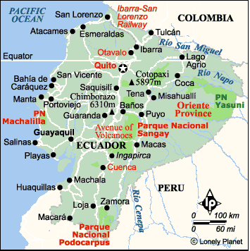
Click
the map above
to see a photo album of Riobamba, Cuenca, Vilcabamba. Close the window
to return to this page
Read Previous
Igor and Friends
or Next
Machu Picchu and Back
Page 1 of
2
Thursday March 6,
2003 Cusco, PeruYou last heard from us in the pleasant
town of Baños. We managed one last walk before we left
town, this time on the north side of town. The
volcano Tungarahua, on the south side of Baños has been
threatening to erupt over the past few years and the only
way out of town is a single lane road heading east and
west. Sometime in the next few years, if the volcano is
patient, the villagers will have a new evacuation route
over a bridge, barely started, that crosses the deep
gorge of the Rio Pastaza. Right now, the only way for
villagers on the north side of the Pastaza to reach town
is to walk up and down a skinny, twisting, impossibly
steep road. Most people lead a donkey to town and ride it
back with their purchases. That road is the evacuation
route and that was our hiking route for our last day in
Baños. It was a hot, but pleasant and quiet walk. Who
else but the farmers coming back from market and crazy
gringos would walk several hours in the heat to get a
view of a volcano that is usually hidden in clouds. One
of the only other people we met on the road that day was
a fellow Ottawan. Another crazy Gringo! But the glimpse
of Tungarahua peak we did get for a few seconds was
lovely.

Only road out of Baños
Our next stop after Baños was Riobamba, whose claim
to fame is the start of a wild train ride called the
Nariz Del Diablo (Devil’s Nose). The rail line once ran
from Guayaquil on the coast all the way to Quito, but
more recent rail closures have left only the section
between Riobamba and Sibambe, mostly as a tourist run.
Construction on the line was started in 1860, but the
Nariz Del Diablo section was left until 1899. It travels
through a particularly narrow and steep canyon and posed
enormous challenges for the railroad engineers. It was
finally completed in 1905 and descends the canyon through
a series of switchbacks and reverses.
That was to be our first train ride in South America,
and it left the next morning. We arrived at noon and had
an afternoon free. A local tour agency said they could
drive us up to see the highest mountain in Ecuador, the
extinct volcano Chimborazo (6310 M).
 Joel picked us up at 2 PM in his old Honda Civic. He
said his car was old but strong and he was right. There
is a road to all the way up to 4800 M on Chimborazo and
it made it all the way up just fine. On the way, we passed herds
of llamas and alpacas and after 4000 M, herds of wild
Vicuñas. They look more like delicate deer than llamas
and have yet to be domesticated, but they tolerated a
pair of curious gringos. Joel stopped the car beside one
small herd and we crept across the altiplano to get
closer pictures. We got within 10 M of them before they
slowly widened the gap. I hope the pictures turn out well.
(They are not great. I need a better zoom lens)
At 4800 M Joel parked the car at a day refugio for
hikers and we got out to walk up another 200 M to a
second refugio. This one is used as a base for climbers
attempting to climb to the top of Chimborazo. The start
of the walk is a wake up call for the unprepared. Stone
memorial tablets commemorate climbers who died trying to
reach the summit. We had been concerned that we would not
even be able to see Chimborazo as it was covered with
clouds when we left Riobamba. Luck was with us. As soon
as we parked at the first refugio, the clouds lifted and
stayed away the entire time we were there. Snowy glacier
tongues extended down the last 2000 M, ending in red and
orange volcanic sandstone.
We walked up to the second refugio and decided to keep
going. We could see a ridge several hundred meters
farther up that looked as if it would give us a view
around to another face of the volcano. We didn’t make it.
The altitude got to me, especially. It was steep climbing
and I was huffing and puffing and taking more frequent
rests. Ray went a little farther but eventually decided
we were running out of time and energy. We made our way
carefully to the second refugio again. We spoke to one
Chilean man waiting for midnight to begin his attempt at
the summit. He and his guide were the only climbers
around that day. I hope he made it. We made a speedy
return trip to the car and told Joel how pleased we were
with our Chimbarazo visit.
The next day was our train ride. The most popular way
to do this trip is to sit on the roof of a box car. It is a five or six hour trip so we
decided the view would be just as good, and more
comfortable, from inside the coach. We got to the station
before 6:30 AM to find one locomotive hooked up to two
box cars and two passenger coaches. People were already
streaming into the station and climbing up on top of the
box cars to claim their piece of roof. Vendors were out
in force, renting cushions and selling warm mittens and
hats for the roof sitters as it was cold in the morning.
We choose our seats inside and soon we were off. To be a
conductor on this train you cannot have any fear of
heights. The inside passenger tickets were easy to
collect, but he had to climb up on the roof of the box
car to collect from the roofers. Even the snack vendors
climbed up on the roof to make a sale.
The scenery was spectacular as we made our way down
the narrow canyon. We stopped briefly at a few small
towns and our longest stop was to hand load a pile of
firewood into one of the boxcars. At the small town of
Alausi we stopped to take on more passengers. There was a
gang of teenaged Ecuadorians all clamouring to get onto
the already crowded roof. A few of the roof sitters had
enough and came inside. The next section was the actual
Nariz Del Diablo. The train descends to Sibambe (really
just a train station), reverses and returns to Alausi.
Just before we started again, the conductor came through
and spoke to me in Spanish. I didn’t understand at first
but then I realized he had issued an invitation to ride
in the engine. Ray and I grabbed our bags and hustled up
to take front row seats for the descent.

Crowd prepared to ride on top of the
train

Preparing to get wheel back on the
tracks
Everything went well for a short while until the
engineer looked out the window and immediately put on the
emergency brake. He and the
conductor got out and walked back along the track. The
first box car with all the roof sitters on top had
derailed. We found out this is not an isolated occurrence.
The entire crew knew what to do. They got rocks and wood
and a steel ramp contraption and positioned everything
under the errant wheel. The engine can be driven from
either the front or the rear, so the engineer got in the
rear of the engine and with much backward and forward
shunting, got the wheel back on the track. All the
passengers were out of the train watching the action and
a few were capturing it on video cameras. Getting one
wheel back on the track caused another one to come off
but finally everything was straight and we all took off
amidst clapping and cheering.
We reached Sibambe where Ray and I were told that our
engine trip was over and it would be nice to leave a tip.
Someone else go to take our places and we found seats
inside a coach. The cars were reversed, the engine
reattached and we were off back to Alausi, or so we
thought. Again, we made an unscheduled stop. This time to
check the braking mechanism. Further on, we rounded a
corner and the same car derailed again! The efficient
crew got busy and we chugged off again. This happened
twice more and then we stopped one final time while a
train crew repaired part of the track in the area of our
first derailment. We limped into Alausi 2 1/2 hours late,
but at least we did make it. One woman told me her
husband had taken the train the previous year and he had
experienced nine derailments! It is still a popular
tourist activity but not for those on a tight schedule.
Ray and I stayed in Alausi overnight and continued on
to Cuenca the next morning. I was glad we had waited
until daylight to make the trip as the scenery through
the mountains was especially interesting. It seemed as if
every time the bus we were travelling on slowly reached
the top of one mountain range in Ecuador, another range
came into view. We would travel from almost jungle
valleys to barren mountain tops every hour. It was seldom
boring. If we got bored of the scenery we tracked our
progress by the clothing of the locals who got on and off
our buses. Each district brought a slight change in each
woman’s skirt, blouse and hat. Often the little girls
would be dressed like their mothers and even the men’s
outfits would change.

Flower market in front of Cuenca
church
Cuenca was a
pleasant town with an attractive Spanish Colonial style
center. It has gained UNESCO World Heritage status so it
is making an effort to retain its colonial charm. We had
one of the nicest hostels to stay in, the Maconde. It was
an old colonial home with high ceilings that has been
converted into a hostel. The rooms are arranged around a
nice indoor sitting area and an outdoor garden and there
was a kitchen available for use by the guests. We ended
up meeting several of the other travellers. One American
woman, who teaches Spanish in Ambrose College in the US
Mid-west, has been coming to Cuenca for the last 8 years
and is now a part owner of the hostel. This year she
brought a group of American students for a one term
exchange program. Cuenca is a popular choice for language
studies.
Cuenca has a number of very good museums, some of
which we visited. The best was the Museo de Banco Central.
The exhibits, owned by the Central Bank of Ecuador, were
housed in a large new building. Besides a collection of
Religious art, they had a great display on the peoples of
Ecuador emphasizing the cultural differences between the
regions. There were tableaux of village life with the
people dressed in clothing that we recognized from our
travels. There were even real shrunken heads, trophies of
the Amazon regions. They claimed that the practise is now
outlawed, but you never know for sure. There was also an
interesting display of an archaeological dig which was
right outside the museum. We walked around to see the
restoration efforts of pre-Inca and Inca ruins of the
original city of Cuenca.
From Cuenca we travelled south again to Vilcabamba, a
small village not far from the border of Peru.
Vilcabamba’s claim to fame is the longevity of its
inhabitants. Several were reputed to have lived for over
100 years, but that has never been verified. Their spring
water is a prize export and their main street is named
‘Eternal Youth Avenue’. The last Inca ruler escaped to
Vilcabamba after an aborted attempt to oust the Spaniards
but he was eventually found and killed. No eternal youth
for him.
We had a recommendation for the Madre Tierra Spa
Resort, just out of town. It was great. It sounded a bit
more expensive than our usual budget places but it was
worth it. The complex is a series of small buildings set
in the midst of banana tress and lush jungle vegetation.
We had a small cabin, complete with a covered veranda, to
ourselves. The breakfast and supper that were included
were so large that we only needed a chocolate bar and
fruit for lunch. The Spa consisted of a small jacuzzi,
free to guests, plus very reasonably priced massage and
other services. I found a jacuzzi soak and a massage at
the end of the day just what I needed after the hikes we
did in the
area.
Our first walk was to the top of Mandango peak, just
outside of town. There were two white crosses on this
peak, the highest one on a rocky outcrop that looked as
if it might have been the plug in an original volcano. We
had an inkling of what we were in for when we reached the
entrance to the trail. We had to pay US$1 and fill in a
questionnaire that asked for our blood type and if we had
any serious ailments! We did get a 500 ml bottle of water
and a small package of local cane sugar to help us on our
way. There are many fields of sugar cane and several
sugar refineries in the area so I guess the free sample
was from the local Chamber of Commerce.
The trail to the first white cross was all uphill, of
course, but not very difficult. There was just one other
small group of hikers ahead of us, two gringos staying at
our hostel and their escort of three locals. The hardest
part of the climb was getting past a barbed wire fence
right on the peak next to the cross.

Mandango Peak
We had a rest to enjoy the view and then looked for
the trail to the second summit. We
could see the other group just ahead of us so we followed
after them. Unfortunately we lost them while we were
picking our way down a steep narrow path from the first
summit. We had seen the first group follow a path around
the base of a sheer cliff on top of which was the second
cross. Around the other side of the cliff we found a path
leading up a narrow ravine. It looked rather steep but up
we went, hand over hand, only to find the trail petering
out. We weren’t sure we were on the right trail, so down
the ravine we went again. We followed another path
through dense brush until it opened out. There was a path
of sorts leading up, so we tried that route. Part way up
we saw the other group had made it to the summit and were
starting down again. We were not on the right route. It
was back down again, through the woods to that narrow
ravine. We had a banana snack to fortify ourselves and
decided we had come this far, why not go all the way.
The second ascent of the ravine was easier and we
found the trail that zigzagged to the top. The path was
one footprint wide and as long as you didn’t look down,
you were alright, but don’t ask Ray to repeat the effort.
We did make it to the top, which was a knife edge ridge,
and the view of all the surrounding mountains and valleys
was spectacular. It did make up for the climb. There was
a cow patty right on that upper path. We had passed
several cows grazing near the trail to the lower cross
but it would have had to be a very sure footed cow to
make it to that narrow summit.
The next day we decided to tackle an easier hike. We
walked on a dirt road leading to the opposite side of the
valley from Mandango Peak. Horseback riding is a popular
activity in the area and one of the favourite rides is to
see some waterfalls farther along the road. About an hour
out of town we came to Cabañas Rio Yambala owned by an
American-English couple. They have built several cabins
nestled in the trees next to a small, swift river. They
offer trips farther into the jungle that sounded great if
we ever make it back here again. Charlie, the owner, gave
us directions to the waterfall, which was another 1 1/2
hours away. We followed his instructions for the first
section, straight uphill for a good half hour. Of course
we had another good view, but we decided we didn’t need
to go all the way to the waterfall. One long day was
enough. Instead, we returned to the Cabañas and had tea
before walking back to Madre Tierra.
Next: Episode 8: Page 2
Return to
Travels
Return to
Introduction