Episode 2: Crossing Borders
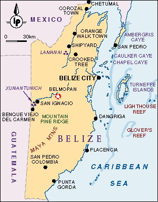
Click
the map above
to see an album of photos for Belize. Close the window to return to this
page.
Read the Previous Epsiode
Riding the Chicken Bus
or next episode
Page 2 of 2
Sunday 27 February
2005 Flores, GuatemalaContinued from
Page 1
The next day we crossed the border by boat into Belize
and arrived in an English speaking country. It seemed
strange not to stumble along with my Spanish for a while.
The country is also more rural and less populated than
Guatemala, with a total population of only 220,000. We
took a bus from Punta Gorda to Independence, a small
coastal town, where we got a motor boat ride through
mangrove swamps to the beach town of Placencia.
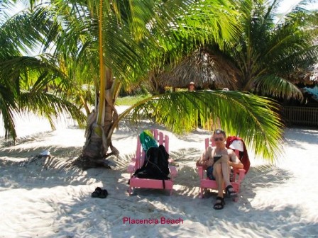 Belize has been
called a Caribbean Island on the mainland, except lower
key and less expensive. Placencia is just one unpaved
road down a narrow peninsula with a parallel paved
sidewalk accessing most of beachside hotels. It is a
quiet, laid back town, just the place to spend a three
days sunning on the beach. We spent our days on the beach
sitting on wooden Adirondack chairs under a palm tree,
breaking now and then for a swim in the ocean. We didn’t
even go for very long walks or any tours, just the place
for Ray to bake out a slight cold.
Sunday night was outdoor band night at a local bar,
the Tipsy Tuna. This was the end event of an Arts
Festival weekend and everyone was there to watch a local
woman perform some energetic dances and to hear the band
play. I talked with an American woman who has lived there
for 14 years. She works in a gift shop and was there
watching her two daughters run the bar. The locals are
worried about overdevelopment as condos start to sprout
up. Since the only way in is a motor boat ride or 20 km
on a bumpy dusty road, it will be a while before it
becomes too commercial.
We continued our
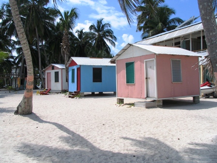
Belize beach experience by going to Tobacco Caye, a four
acre sandy island a half hour boat ride off Dangriga. The
coral reef sweeps around two sides of the island forming
a shallow lagoon about 90 meters wide, home to several
water birds. We stayed at Gaviota, one of the five mini
resorts on the island. We had a simple cabin on stilts
facing the lagoon. Gaviota tries to be environmentally
friendly, so electricity is solar powered and water comes
from rain storage tanks or is pumped from underground and
filtered. Bathrooms are communal and have big signs
warning you to conserve water. There are no stores or
restaurants on the island so all meals are provided and
served family style in a central dining room. There were
only 12 to 14 people staying there so we got to know
everyone.
 The snorkelling was great. We rented masks and
flippers and swam right off the shore. We swam over the
shallows a short distance to reach the far side of a
coral reef. There were lots of colourful live corals and
lots of fish to see. We tried to identify some of the
fish but there were too many kinds to remember them all.
Each evening a pair of large spotted Eagle Rays cruised
the shallows beside the main dock and an Osprey sat on a
nest on top of a fishing shack in the water. Our last day
there I was invited to join three other woman on a boat
ride to another coral reef about three minutes away. I
had a great time exploring more of the ocean and watching
a stingray glide by underneath me.
After three days it was time to leave. We took the
boat back to Dangriga and stopped at the bank to
replenish our money supply and at the internet to do
internet banking. We were told the bus to Belize City
left at 10:30 so we were not rushing. We arrived at the
bus just in time to see the bus take off at 10 AM, and
the next one was at noon. There was nothing to do but
wait and to decide where we were going next. We had a
choice of more snorkelling on Caye Caulker or going to
Crooked Tree Wildlife Sanctuary, where Jim and Ginny
Galway had recommended the bird watching. They both
necessitated going through Belize City. We phoned Sam
Tillett’s at Crooked Tree (we usually just turn up and
find a place to stay) and they had an opening that night.
It pays to be flexible.
The bus, a recycled school bus arrived at noon and off
we went. The bus started labouring on little inclines,
then racing down hills in order to make the next hill. We
were concerned we would not make our half way point,
Belmopan, but we did. I was surprised that we got on the
same bus after a short ten minute break and sure enough
we encountered engine problems very shortly. While still
driving, the bus driver flipped up the engine cover,
which was beside him inside the bus and instructed the
ticket taker to hand pump the fuel pump. The driver
replaced the cover and we would go another 100 M until
the engine starting dying again. This was repeated
several times until the ticket taker was pumping almost
full time. The driver didn’t even dare stop to take on
passengers. The end came when the bus stopped to let off
a passenger and couldn’t start up again. Just as I was
contemplating our chances of hitch hiking, another bus
came along and we all piled on for the rest of the trip
to Belize City, still in time to make our connection to
Crooked Tree Junction.
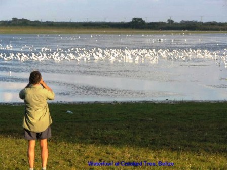
Crooked Tree is an island in the middle of a river and
lagoon system. It is one of the last water sources in
Belize to dry up so it is a haven for all kinds of
waterfowl and fish eating birds. Sam Tillett’s was full
of Canadians. In fact, we have met more Canadians and
Americans on this trip than anywhere else we have
travelled. I guess the proximity to the US and Mexico
makes it easier and less expensive to reach than Europe
or Asia, plus the climate is not hard to take in the
winter.
We joined three
Candian women, ESL teachers from Calgary, on a birding
boat ride at 6 AM the next morning. Sam Tillett was
elsewhere but our guide Rufus knew his birds. We relaxed
for several hours floating down the river system with
Rufus pointing out specie after specie. When we got back,
I went through the Birds of Belize book and counted 44
different ones, including all the herons, egrets, Jabiru,
ibis and several different hawks.
We also caught sight of a green iguana in a tree and
floated down a crocodile infested section of the river.
Rufus claimed they didn’t go after people but were
partial to dogs. I offered up one of the dogs near us
that bark in the night and Rufus told us the tale of why
crocodiles like to eat dogs. It seems that Dog tricked
Crocodile into giving up his tongue one time and ever
since Crocodile doesn’t waste an opportunity to snatch
his tongue back from Dog.
On our way back to Sam Tillett’s we saw a pair of
Laughing Falcons. Before leaving Ottawa I had picked up a
book, The Laughing Falcon, a suspense story set in Costa
Rica, written by William Deverell, author of Street
Legal, the TV show. He lives on Pender Island off
Vancouver and winters in Costa Rica. It is a good light
read, if you come across it.
 That afternoon
Ray and I decided to go on a little walk on some trails
in the surrounding woods. We did everything wrong. We
thought we were only going for a short walk so we had no
water, no hats, and no sunscreen. We met another couple
from Sam Tillett’s who gave us half a small bottle of
water and told us the boardwalk, admittedly some distance
away, was worth the effort. After being out about four
hours and seeing very few birds, I didn’t agree but we
did not suffer from the experience for long. After a soft
drink and a short rest we were ready to join two more
couples from Calgary on a sunset walk to the water to see
flocks of herons and egrets fish for their supper.
The next day we took the bus back to Belize City and
got the water taxi to Caye Caulker, 32 km north. Belize
has 290 km of barrier reef off the coast. The water is
very shallow on the west side of the reef, allowing many
small islands, the Cayes, to surface. Tobacco Caye was
one but Caye Caulker and Ambergris Caye are the most
popular. Caye Caulker is the simpler and less expensive
of the two so that is where we went. The Caye is about 6.5
sandy km long. The 1961 Hurricane Hattie, that also
destroyed Belize City, widened a channel in the middle,
splitting the island in half. The town, a string of
hotels and restaurants, is on the southern portion.
We found a nice
room at Tom’s Hotel, facing the beach and looking out at
the barrier reef about 1 km offshore. The swimming along
the beach isn’t the greatest as sea grasses thrive in the
shallow waters. We preferred to walk to the Split where
there was a sandy beach and lots of fish beneath the
pilons left from a collapsed bridge. Ray liked the
sunbathing and bar scene at the Split.
We joined six others on a guided snorkelling trip to
the local reef one morning. We were gone for three hours
with stops at at three different locations. The first
spot was quite shallow so the guide led us single file
through the gaps in the corals. Our guide, Salvador was
very good at pointing out the various corals and fish,
including a large, lazy, ugly porcupine fish.
 When
When
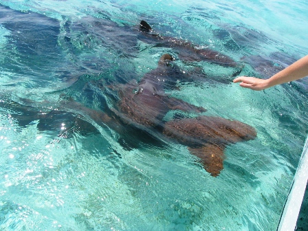
we had enough we moved to Shark and Ray Alley, where we
were greeted by, you guessed it, a school of Southern
Stingrays and several Nurse Sharks (a harmless variety).
They have learned that all the snorkle boats bring fish
to hand feed them so they were waiting for their treats.
We were invited to swim with them so we jumped in.
Salvador let us pet both the stingrays and the sharks.
They had a soft, slippery feel, not unpleasant. The
stingrays in particular stayed around for quite some time
before deciding the snacks were gone. Our last stop was
similar to our first stop but deeper. We were allowed to
pick our own route here so Ray and I went out exploring.
The fish were just as colourful, but a bit larger and
more plentiful in this spot and we had a great time.
Our last stop in Belize was St Ignacio, just 17 km
from the Guatemala border. This was to be a stopping off
place on the way to Tikal, but there are several other
Mayan sites in the area. After lunch we started walking
to Cahal Pech, on the edge of town. A pickup truck driven
by an American stopped and offered us a ride. We got in
and told him where we were headed but he misunderstood
and went past where we thought the turnoff was. He
thought we were going to Xunantunich 12 km away. He
offered to take us back, but since he was going to the
town near Xunantunich and it was a more significant site,
we elected to continue on.
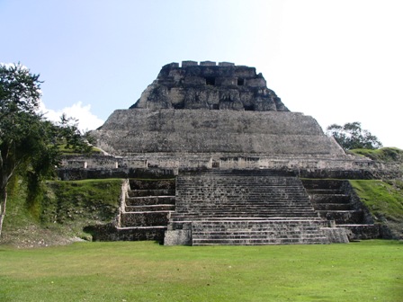
Large temple at Xunantunich
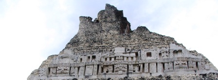
Detil of carvings on a temple
We
stopped where a free ferry takes you to across the Belize
River. Our driver offered to take us all the way as he
said it was a 2 km uphill walk on the other side, so of
course we agreed. The site is
dominated by El Castille, a pyramid rising 40 M above the
jungle floor. We climbed the steep stairs for a great
view. Carved masks were discovered and restored on the
east and west sides of El Castille. To preserve the
carvings from erosion by the elements, fiberglass
replicas were made of the carvings on the west. The
originals were buried about 1 M below the surface and the
realistic looking fiberglass replicas are what you now
see. There seems to be a debate amongst archaeologists as
to what is better, to allow people to view the ruins and
risk deterioration from the elements, or to uncover and
study them and them rebury them. It seems a little too
elitist to limit views to a few archaeologists, plus I
would guess that funding is more readily available to
accessible sites.
After viewing the rest of the buildings at
Xunantunich, we started walking down the road towards the
ferry. Another pickup truck stopped and offered us a ride.
Since they were returning to St Ignacio, we got a ride
all the way. There seems to be a lot of missionary
activity in Central America. The first fellow to pick us
up was an American who had been working at a Jehovah’s
Witness mission for two years. The second group were
Mennonites, including a young man, who was deaf and
taught at a school for the deaf in St Ignacio. His parent
were visiting from Sharpesburg, Maryland. That evening we
had supper in a nice outdoor patio restaurant in St
Ignacio. We sat next to a large group of Americans
visiting a Roman Catholic mission. The priest with them
was telling them about his work teaching at a local
university and a seminary as well as taking care of a
parish. Whatever their beliefs, they were all most kind
to us.
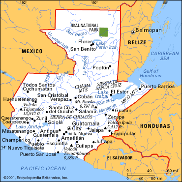
Click the map above to see an album of
photos of Tikal. Close the window to return to this page.
We took another early morning minibus from St Ignacio
across the border to Guatemala. We had tried to get a
reservation to stay at the Tikal site but they were all
full, so we were heading to our second choice, El Remate,
on the shores of Lago de Peten Itza, about a half hour
away from Tikal, the largest Mayan site in Guatemala. The
rest of the minibus group were travelling to Tikal for a
day tour but we were in no rush.
We found a good
room in El Remate, just a collection of small hostels at
the junction of roads to Tikal and around the lake. We
walked down to the lake where local women were washing
clothes on makeshift platforms of piled up rocks. The
water is swimmable but the muddy shoreline didn’t entice
us. It was too hot in the afternoon to do anything but
relax, which was fine with us. We did manage to find a
balcony restaurant overlooking the lake where we had a
beer while admiring the sunset. Life is tough.
The next day we did Tikal. A minibus picked us up at 5:30
AM to drive us to the site. We shared a guide, Juan, with
three Americans from California. Juan was pleased to
share his knowledge of the Mayans and Tikal with us. The
site is huge. The 550 sq km park in which the central
area of the city occupies 16 square km and more than 4000
structures, only some of which have been uncovered. The
Mayans kept the location secret from the Spaniards, so
they lay undisturbed until 1848 when a Guatemalan
expedition gave out the word. Several countries have been
involved in their exploration and work continues today.
Clearing is slow and laborious. The trees growing on the
hidden temples must be cleared gradually to prevent the
collapse of the structures. All the stones must be
numbered and reconstructed using materials as near to the
original as possible.
We started our tour so early for a reason. It
gets hot when the cloud cover dissipates later in the morning. We had
been warned to bring lots of water and snacks and to wear good walking
shoes for the 10 km of trails through the complex. It was good advice.
We took our time and enjoyed the multitude of pyramids and temple
structures. High stone steps or wooden staircases on several pyramids
allow you to reach heights of over 40 M. What stuck me most was the
obsession with numbers. All the temples have elements arranged according
to the numbers 3, 5, 7, 9 and 13. Every element of each structure was
significant. As many people know, their astronomical calculation were
phenomenally correct, including adjusting for leap years. They
calculated time in 13 cycles of the moon and groups of 20 and 52 years.
In addition, Juan told us that the seven main buildings of Tikal have
the same configuration as the seven stars of the Big Dipper.
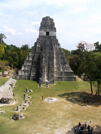
Climb the temple to the sanctuary on
top
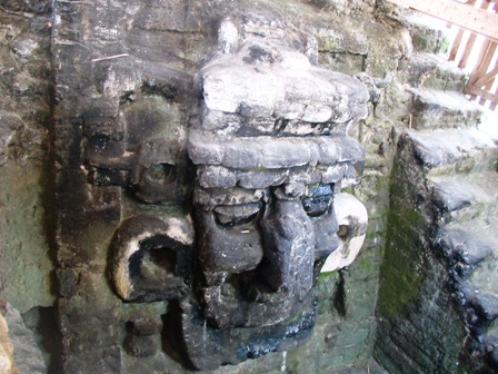
One of many carved faces
Our tour ended at 1 PM, allowing us time to visit the
local museum with a small but interesting collection of
pottery and a reproduction of the grave of one of the
last rulers, King Moon Double Comb. He was found
surrounded by 16.5 lbs of jade. Juan told us that the
Guatemalan Jade has been determined to be Jadeite, but
the Jade found with the body is the real stuff, implying
it had to come from China or elsewhere in Asia. More
people are concluding that there must have been travel
and trade between far flung regions of the world. There
has to be some reason that pyramids are found in Egypt,
Central and South America as well as South East Asia.
We are now in Flores, just 35 km around the lake from
El Remate. We are stopping here so that I can write the
latest episode and to catch the bus tomorrow heading
towards El Salvador. That will mean another border
crossing and more stamps on our passports.
As usual, we have visited quite a number of places but
there is always more to see. We keep hearing of
recommended places we have not had time to visit, but
that will have to wait for another time.
Back To: Episode 2: Page 1
Return to
Travels
Return to
Introduction