Episode 2: Coromandel to Waitomo
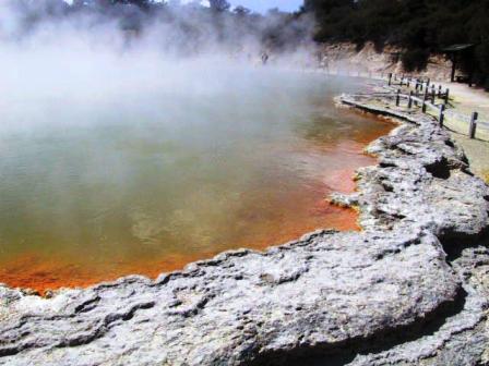
Multi coloured geothermal at Waiotapu
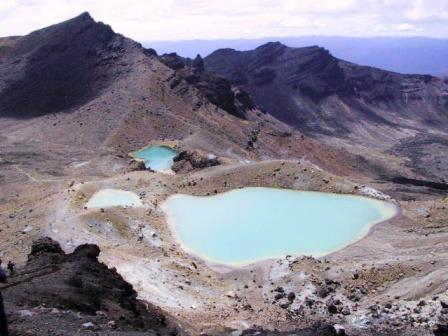
Emerald Lakes in Tongariro National Park
Read Previous Episode
Auckland to Coromandel or Next
Rotorua Hikes to Havelock
Episode 2: Page 1 of 2 Thames to Tongariro
National Park
Wednesday, 19
December 2001, Rotorua, NZ
Skip to
Episode 2: Page 2 Coromandel to WaitomoYes, there is still more
rain than sunshine, but we are coping very well. We’ve
changed our plans slightly but haven’t missed much. We
have been surprisingly lucky in that the rain has always
stopped long enough to visit the scenic spots. We have
passed a number of bicyclists pedalling up the hills on
our travels. I don’t think there has been a day where
they did not get soaked. It makes me glad we are driving,
not cycling.
Since you last heard from us, we have explored more of
the Coromandel Peninsula, explored the geo-thermal areas
around Rotorua and Taupo, taken our first three-day tramp
and visited some of the Waitomo caves. No sitting around
for us.
On our way out of Thames on Saturday Dec 8, we got
caught up in a Saturday morning sidewalk sale and mussel
fritters are a town speciality. Even though we had
finished our breakfast not long before, we couldn’t
resist. These tasty and rather filling treats were more
like a mussel burger and came served on buttered bread.
Not exactly a fat-free meal. We picked up a bottle of
another town speciality, fresh pressed apple juice. It
looked like grapefruit juice, but was sweeter than
commercial apple juice. It went well with the mussel
fritters.
We weren’t travelling far that day anyway, just across
the peninsula to Tairua. The backpackers hostel there had
one of the nicest properties and facilities. Like most of
the places we stay in, it had both dorm, or multi-bed
rooms and double and twin bedded rooms. We look for a
double room. The toilet and shower rooms were down the
hall and there was a large well equiped kitchen. We
bought an insulted bag and a freezer pack to keep our
perishable food and we store these in a labelled bag in
the communal fridge. Our non-perishables are carted
around in a cardboard box and stored either on a shelf in
the kitchen or in our own room. We buy fresh fruit and
veggies and meat to cook our selves when we are in a
backpackers, but we stick to pasta mixes and tuna when we
are tramping. Tairu Backpackers even had a few old cars,
painted up with their names on for people to borrow;
great advertising for them. They also had kayaks,
sailboards and bicycles for the use of their guests, but
we didn’t get to use them in the wet weather. The weather
socked in for the afternoon and we just vegged.
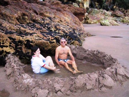
Hot Water Beach
Our plan was to visit the famous Hot Water Beach
nearby. The beach has hot springs under the sand that
are only accessible at low tide. When we woke up in the
morning, it was not raining so we stowed borrowed shovels
from the hostel in the boot (trunk), took off, and
arrived at the beach a half-hour before low tide at 8:30
AM. Several people were already installed on the beach in
their little ‘spas’. The easiest way to find the hot
spots is to dig your feet in the sand near the existing
spas. You know you have hit the right spot very soon and
the springs are boiling hot. That’s why you have a
shovel, for you need to hollow out a tub-sized area with
sand walls around it to keep out the encroaching sea.
This can be difficult if the surf is high or you are a
little late getting to the beach. You no sooner build one
wall than the waves crash them down. We got lucky. We
were invited to share a good-sized spa with one young
lady. Her family had built it earlier and had abandoned
the site in favour of breakfast. We were only too happy
to bask in the warm waters and help reinforce the walls
whenever the waves threatened them. A family with a baby
and a small child joined us and we all had a great time
playing in the sand. There were signs warning of a very
strong undertow in the area and the water was quite
chilly, so we didn’t stay to have a swim. We had other
places to visit that day.
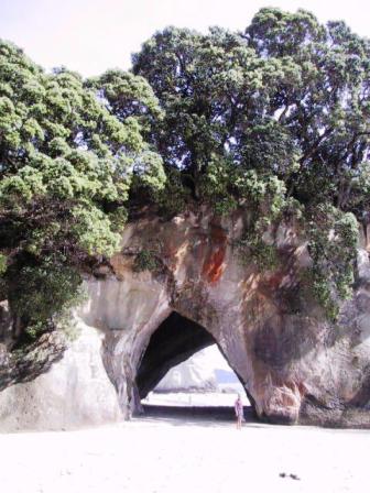
Cathedral Cove
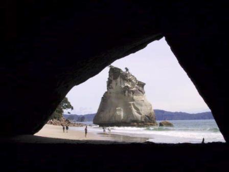
Natural rock arch in the cove
Just up the coast
is Cathedral Cove, also best visited at or close to low
tide. There was a sign at the car park indicating a 50-minute
walk to the cove, so we hustled down the path, passing
several other tourists on the way. We made it in record
time and had lots of time to explore. We descended to a
small cove, past a lovely waterfall and reached the
adjacent Cathedral Cove through a natural rock arch. As
we walked along the beach in the second cove, admiring
the Flower Pot rocks, like the ones on Hopewell Beach in
New Brunswick,
a pair of Oyster Catchers accosted us. They were not at
all shy but if we got too close to them, they very
definitely let us know. We soon realized they had a nest
right at the back edge of the beach. It was not a well-chosen
site. We tiptoed past and returned to the car park on the
walking path.
On to the next stop. A few K further up the road we
turned off and ascended 1 K up a steep and twisting side
road to Shakespeare’s Cliff. Besides giving a great view
of Mercury Bay, you get a little of the local history. It
seems that Capt Cook named the bay after he witnessed the
transit of the planet Mercury across the sun from this
very spot in 1769.
Back down the hill we went on to the tiny village of
Ferry Landing, where, you guessed it, we took a ferry, to
Whitianga, a 5 minute trip. This was our lunch and
grocery buying spot. We chatted to a fellow backpacker on
the return ferry and when I noticed him checking the
local bus schedules, we offered him a lift. He was from
Boston and was hitch hiking and bussing it. The previous
day he had hiked up to the highest peak in the northern
part of the Coromandel Peninsula with a local and
confirmed that we had made the right decision by staying
put. He spent most of the time in the rain slogging
through boot high water: not fun. We dropped him off at
Hahei Beach, a resort town near Cathedral Cove.
There was one more sight to see before we made it back
to our hostel. We had to see what Tairua looked like from
the top of Mt Puka. A roadway snaked around the hill
about ¾ of the way up. From there we hiked for 20
minutes through a forest and up a rocky slope. Yes, the
view was worth the climb. We looked down on Tairu, on a
bay leading to the Pacific Ocean, and surrounded by small
islands. Just across the bay was the resort town of
Pauinui, built on reclaimed land. To the west, we could
even see Pinnacle Mountain, that we had climbed a few
days before. A fitting end to our Coromandel visit.
We had a bit of sunshine for our departure from Tairua
on Monday, but the clouds and light rain soon moved in
and out all day. We managed to miss our turn just out of
town, but that turned out to be a bonus. We travelled
through the scenic Kauaeranga Valley, then discovered we
would be passing by the Karangahake Gorge on our detour
south. This warranted a visit. We took a half hour walk
down a path cut into the side of the narrow gorge. The
river below us was filled with rapids and caves, the
remains of abandoned gold mines, opened to the side of
the trail. If we had planned better, we could have spent
most of the day exploring the area. Instead, we continued
on to Rotorua and the Funky Green Voyager Backpackers. We
spent the rest of the day stocking up on groceries and
taking advantage of the sales in the MEC-type outdoor
store, Kathmandu.
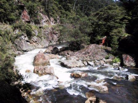
Karangahake Gorge
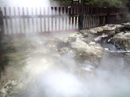
Te Whakarewarewa village geothermal
steam
Rotorua is famous for its geothermal areas, so the
next day we visited the Te Whakarewarewa village (‘wh’ is
pronounced like ‘f’). The Maori villagers have been
showing visitors their geysers, craters and blow holes
for more than 100 years, and they still live in the
village. Some of the front yards of the houses
have their own craters, where they often cook their food
and new ones appear all the time. Included in your
admission is a guided tour of the area and a Maori song
and dance performance, similar to the one we saw in
Auckland. We enjoyed it just the same. After the show we
were free to visit the area on our own and we took them
at their word. We managed to find paths that got less and
less distinct and seemed to be leading out of the village
boundaries. Trust us.
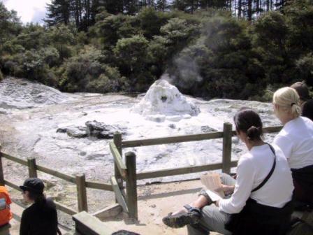
Lady Knox Blow Hole
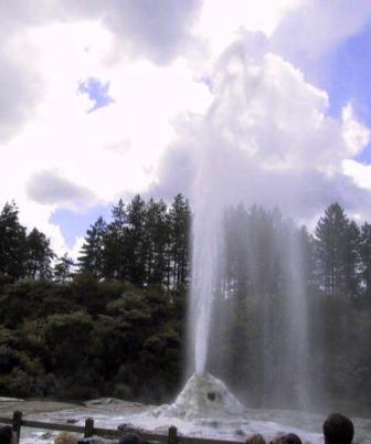
Thar she blows!
The other geothermal areas we wanted to visit were on
the way to Taupo, so Wednesday we packed up and moved
again. Just south of Rotorua is Waiotapu, a favourite of
bus tours but well worth the visit. We had been told to
get there before the scheduled eruption of the Lady Knox
geyser at 10:15. We
were there in time to have a preview of the craters and
blow holes in the main park, then we jumped back into
Alice and followed the stream of cars 1 K down the road
to another parking lot. Seated in a large amphitheatre
nearby were scores of other tourists all waiting for the
promised show. A park employee arrived to warm up the
crowd and to give us the history of this geyser. In 1901,
convicts were brought into the area to plant pine trees. Some of them
decided to take advantage of the natural hot springs to
wash their clothes. They dumped some soap into this
particular geyser and proceeded to scrub away. All of a
sudden, the geyser erupted and their clothes shot
straight into the air. Apparently the soap changes the
surface viscosity such that pressure is built up and the
geyser erupts. All this was explained to us while the
announcer poured 1.5 Kg of pure soap flakes into the
mouth of the geyser. It foamed away for a few minutes and
sure enough, it blew on schedule, about 10 M into the air.
Everyone snapped away while the geyser just kept on
erupting. We left before it was even finished because we
wanted to return to the main area.
The
sights were truly amazing; huge craters, smoking blow
holes, black water pools, lime green pools, multi-coloured
rocks, and a huge bubbling mud lake, all in very well
kept surroundings. We didn’t need to fear the crowds as
the area was large enough for everybody to spread out.
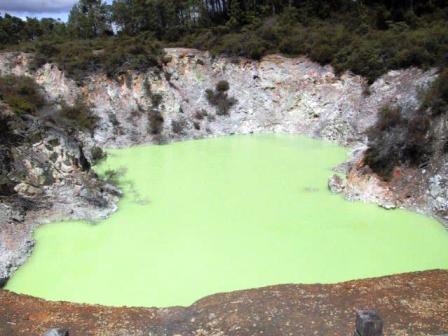
Green Pool
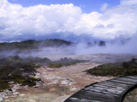
Craters of the Moon
It started to rain again just after we left Waiotapu,
so we ate our picnic lunch in the car, right near the
Huka Falls lookout. Even in the light rain the falls were
impressive. They were not very high, about 3 – 4 M, but
the volume of water rushing through the narrow gorge made
up for the height.
In the same area was the Craters of the Moon. This large geothermal area came into
existence in the 1950s when the construction of a local
power station altered the ground water levels. Suddenly
several acres of new steam vents, craters and mud lakes
appeared. The site is now administered by the Department
of Conservation (DOC) and as a bonus, is free to visit.
We spent about two hours walking the wooden boardwalks
around the area. The rain even stopped for us. Great
clouds of steam emanated from many of the craters, a
benefit of the recent rains and subsequent rise in the
water table level.
Taupo was a let down for us. Our room was a tiny cubby-hole
with a small window opening to the main action area. The
place was full, over crowded as far as I was concerned.
We had planned to stay two nights, but cancelled the
second night and moved on to National Park, at the edge
of the Tongariro Reserve. That was the best decision we
made. We wanted to do the Tongariro Northern Circuit, a
three or four day tramp, and the weather had to be good
to enjoy it properly. We decided to do the three day
version and we were in luck. Friday was the best day for
the last month. It was clear and not too hot, just
perfect for walking. We caught an early bus taking us and
several others to the start near Mangatepopo Hut. We
weren’t the only ones to realize this was the day to hike.
Our first day of the hike is the same as the Tongariro
Crossing, reputed to be the best one-day hike in NZ. I
would agree that the scenery is spectacular.
There was a steady stream of trampers on the route,
but close to 90% of them were on the one day hike. The first ½ hour
was a flat walk to the base of the hills, then there was
an hour walk straight up the rocky path. I let the
keeners pass me, but we eventually caught up with many of
them. Once up the steep hill, we were confronted by the
black volcanic Mt Ngaurahoe. There was a three hour side
trip to climb to the summit of Ngaurahoe, but we just
opted to watch people snake their way to the top. We were
told later it was a difficult climb. You were rewarded by
a view to die for at the top, but you had a choice of
walking up black sand, two steps up and slip back one, or
climb hand over hand up a rocky cliff. On top of that,
those who hiked up arrived at the first hut too late to
get a bed! They had to sleep on the floor.
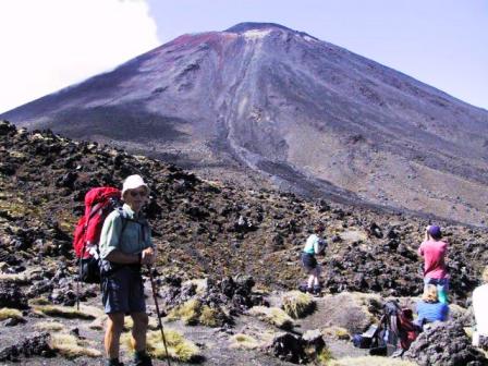
Tongariro Crossing Trail
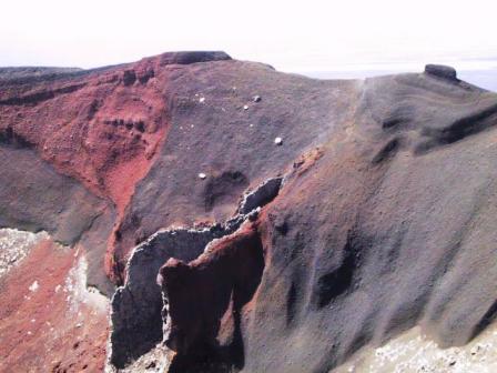
Red Crater
Just
past Ngaurahoe was the smaller peak of Mt Tongariro,
another side trip we opted not to take. Instead, we
gawked at the Red Crater, a huge, active crater with dark
rust red sides. In fact, the whole area is still active.
Mt Ngaurahoe last erupted in 1975 and Mt Ruapehu, whose
snow covered sides we could see beyond Mt Ngauruhoe, blew
in 1995 and 1996. There was almost no vegetation at all
the first day, just bare volcanic rock and sand. From the
Red Crater, you look down on the Emerald Lakes, with
waters that sparkled in the sun and just as green as
their name implies. Many of the trampers rested there to
eat their lunch, but we opted to take our break just a
bit farther on at Blue Lake, really almost as green as
the Emerald Lakes. The colour of the lakes is determined
by the mineral salts present in the water. After lunch we
had an easy ¾ hour walk down the longest switchbacks I
have seen, ending at Ketetahi Hut. I thought the person
who laid out that track must be sitting somewhere having
a good laugh at our expense.
We got to Ketetahi before 2 PM, after 5 hrs 20 mins on
the trail. I thought we did very well. The trampers who
were already at the hut were lying or sitting on the
sundeck, enjoying the view of Lake Taupo and Lake Rotairo
in the distance and resting before the final 1 ½ – 2
hour walk down to the road where buses arrive to take
them home. One fellow looked at me and said, “I know
you, you picked me up at Ferry Landing”. It was the
hitchhiker from Boston.
We
claimed our beds in the hut and just took it easy. The
hut had beds for 26 people spread between the one main
room and two extra bedrooms. The main room had gas
burners, a wooden table and benches for meals. We chose
two places out of the four on the lower bunk in a side
room. It didn’t take long for all the beds to fill up.
There is no booking system for these huts. It is first-come-first-served,
so after 4 PM you had a choice of sleeping in your own
tent outside or sleeping on a thin foam on the floor
inside. The final head count was 33 inside and 10 in
tents outside. Despite the numbers of people, everyone
was very cooperative, sharing the cook stoves and table
space.
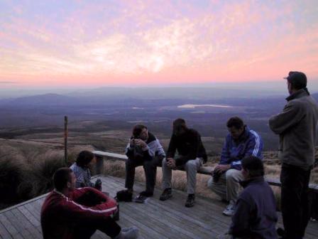
Sunset at Ketetahi Hut
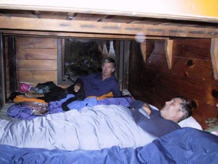
Sleeping platform in Ketetahi Hut
The
sunset that evening was as good as a paint-by-numbers
picture. The dying sun painted stripes on the wispy
clouds in one direction and sponge painted the clouds in
another direction. It was almost as if an alarm clock
went off with the setting sun. Everyone was in bed and
asleep shortly after 9 PM. No big partiers here.
We were all up with the sun the next day, ready for
Day 2 of our hike. People were making sure they reached
the next hut in time to claim a bed. In fact, not
everyone was going the same way and it was not a problem.
Some had hiked the circuit in the opposite direction and
were on their way out. We were off before 8 AM, retracing
our path to the Emerald Lakes. I could see the value of
the switchbacks on the way out, it was a piece of cake.
We spent the day changing our outfits. We started out
with long pants and a light fleece and Ray shed both part
way up the hill. The wind came up at the turn off from
the Emerald Lakes and we put on rain jackets. In fact,
the wind was gusting so strongly, I could feel it
catching by backpack. Thank goodness, we descended into
the protection of a valley and took off our jackets again.
We had 1 ½ hrs walking across the moonscape of
valleys and ridges of volcanic rocks swept down during
the eruptions of Ngaurahoe and Tongariro. We made it just
in time to Oturere Hut, our half way point for the day.
It started to rain just after we got inside for a break.
We got out our full rain gear; pants, jackets and bag
cover and waited until the rain let up. We continued on
in light, but steady rain for about ½ hr, until it
finally stopped and we could get rid of the hot rain wear
and get back to shorts and t-shirts.
Just when we thought we were getting bored by the easy
but barren landscape, we came to the only forest in the
area. Waihohonu Hut, our destination, was somewhere on
the other side of the hill. We entered dense woods of
North Island Beach, with tiny leaves unlike any North
American Beach tree. We crossed a roaring brook and then
started straight up. Time to change gears and stop
frequently for water breaks. Finally we came out of the
woods on the top and saw the hut below us. It took us 6
hrs 20 minutes that day, but we were feeling fine.
The layout of Waihohonu hut was almost the same as
Ketetahi, except there were an extra 3 beds, 29 in all.
There were just 18 people in the hut that night, and 8
more in tents outside, not an overflow crowd. The hut
warden was American. You can volunteer to be a hut
warden, and if you have first aid training and
appropriate experience, you are provided with free room
and board for a two month stint. A Swiss girl was the
warden in Ketetahi hut and her husband was in
Mangatepopo, where we started our tramp. They all seemed
to be enjoying the experience.
Read Next:
Episode 2: Page 2 Coromandel to Waitomo
Read about our visits to the
Cook Islands or
Fiji
Return to
New Zealand
Intro
Return to
Travels
Return to
Introduction