Episode 1: Auckland to the Coromandel
Peninsula
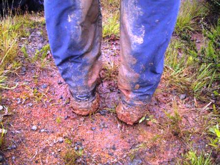
A muddy walk to Pandora Bay
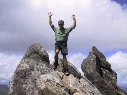
Ray on top off Pinnacle Peak
Read Next
Episode 2: Coromandel to Waitomo
Episode 1: Page 2 of 2 Matauri Bay to Pinnacle
Peak
Friday, 7 December
2001, Thames, Coromandel Penninsula
Continued from
Episode 1: Page 1 Auckland to
Russell
Friday we were off again, heading north through fog
and kiwi mist. Of course, we took one of the side roads
leading to the sea, this time to Matauri Bay. We parked
and walked along the beach, popular with surfers, more
than 1 K of crushed seashells with the waves rolling into
shore. The beach was striped with white lines of jellied
foam that seemed to mark the progress of the tide. One of
the surfers told me this was plankton, a favourite of
fish and whales.
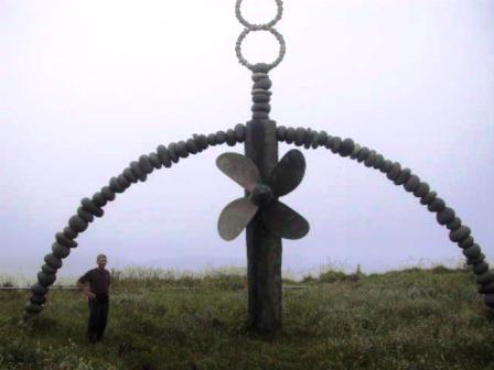 Matauri Bay is the site of a monument to the
Greenpeace ship, Rainbow Warrior, which was bombed in
Auckland harbour in 1985. The ship had been about to sail
to Moruroa, near Tahiti, to protest nuclear testing by the
French. The French, in their wisdom, sent secret service
agents to stop them. The ship was blown up and a
Portuguese photographer on board was killed. The skeleton
of the ship was towed to the Cavalli Islands and sunk,
about 3.5 K off Matauri Bay. It is now a favourite diving
spot. We walked up a hill at the end of the beach to see
the monument, built of large rocks, in the shape of a
rainbow. It was a lovely peaceful spot and very moving.
We stayed that night in a backpackers hostel in
Kaitaia, the largest town before Cape Reinga. It poured
rain overnight, but the next morning it looked as if it
was clearing so we drove up the Cape to Waitiki Landing.
As far as I could tell, the town of Waitiki Landing,
where we stayed, consisted of a backpacker motel,
restaurant and gas station. That is all.
It was still early when we arrived so we set out to
try one of the ‘short’ walks in the area, to Pandora’s
Beach. The first ½ K was fine, but the road quickly
became a muddy track with all the rain that had fallen in
the past few days. The red mud stuck like clay to our
boots and I swear I grew a few inches in height.
Part way down the trail we branched off on a side
trail to see a small Kauri bush. These huge trees, native
to NZ, only grow in the north island. Some reach heights
of over 50 M and are thousands of years old. We had been
walking steadily uphill, following a ridge with reputed
beautiful vistas on either side, now shrouded in cloud,
but the side trail went downhill, sharply downhill. It
was so steep and slippery we had to hang onto the trees
to keep from falling. Near a stream at the bottom of the
hill, we did find several Kauris that were quite
impressive to us. Just as we were admiring them, the
heavens opened and we scrambled to get our rain jackets
on and seek shelter under a fern tree. We nibbled on our
lunch until the rain stopped and made our way up the hill
again. Luckily it was easier climbing up than the descent.
We decided to continue on to the beach and as we got
nearer and could hear the surf, the visibility improved.
Pandora’s Beach was several K of deserted beach, just the
thing for a hot day, but not that day. Ray went down the
beach looking for a no-longer-there hut while I took my
boots off and rested my feet. By the time we had retraced
our steps and reached the car, we had hiked five hours, a
little more than a short walk.
 That night it rained, and it was still raining in the
morning, even thunder and lightning. We wondered if we
should just call it quits and move on or wait another day.
We did want to see the fabled 90 Mile Beach, so we opted to
have a lazy day and hope it cleared soon. We were in luck.
After lunch, the rain stopped and the skies cleared
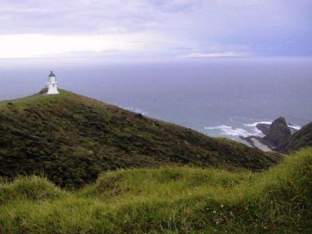
enough to encourage us to drive to the northern most
point in NZ, Cape Reinga. By the time we were in the car
park at the point, the clouds were gone and we had a
lovely view from the lighthouse of the distant islands
and the waters, where the Tasman Sea and the Pacific
Ocean meet.
On the way back to Waitiki Landing, we tried, without
success, to tramp to a beach. First we followed the signs
to Te Werahi Beach, but turned around as the path led us
into a swiftly moving river, once a boardwalked swamp. We
tried a second path to Twilight Beach. This path looked
promising at first as the promised boardwalk was
passable, but the bush beyond it was now a swamp. We
managed to navigate several detours at first by jumping
from one grass tussock to another, but we eventually gave
up and contented ourselves with a walk back across
pasture land.
Near Waitiki Landing, we decided to have a look at Te
Paki stream. This is one of the entrances to sand dunes
and the 90 Mile Beach. We had been told that tour buses
could navigate the stream at low tide, but that rental
car companies have a clause in their rental agreements
cancelling insurance if the cars are taken on the beach.
We had thought that the tour buses just had to cross the
stream to get to the beach, but we found out the buses
drive about 1 K down the middle of the stream to get to
the beach. We knew Alice
wouldn’t like this, so we parked and walked across the
stream in our bare feet to the sand dunes on the other
side. They were huge and extensive, just like the Sahara.
We hiked up to the top of one of highest dunes to have a
look around. We could see nothing but more dunes between
us and the sea, about 1 K distant. We watched a jeep
arrive, drive part way down the stream, park and unload
small surf boards. A favourite activity is surfing down
the dunes on boards or plastic sleds. We watched the jeep
passengers hike up the hill and slide down, but they
didn’t get very far. The sand was too wet. Not good for
sliding, but easier for walking. We had no trouble
leaping down one of the steeper slopes. It was great fun.
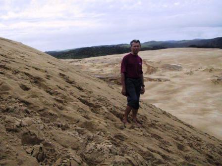
Ray on the sand dunes
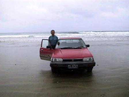
Alice drives on 90 Mile Beach
On Monday we left Cape Reinga, but not before taking
Alice to the beach. Further south from Waitiki Landing we took
an easier access road out to 90 Mile Beach to have a look.
The white sand beach is actually 105 K long, but that is
longer than any beach I have seen. The tide was quite low
and there were a few cars parked on the beach near the
water’s edge, so it looked safe enough for Alice. She
loved it. The sand was hard all the way to the water, so
we drove a short distance down the beach and back again.
Then it was on the road again, back south.
We made one stop near Kaitaia to visit the Ancient
Kauri Kingdom, a commercial kauri woodworking shop. Their
claim to fame is a huge kauri trunk, found submerged and
perfectly preserved in a swamp. The owner of the shop
carved a staircase in the center of the trunk and it is
used as access to the second floor in the shop. All the
wooden furniture and gift items in the shop are carved
from kauri stumps left over from long ago logging
operations, or found in swamps.
We were headed for the little town of Omapere on the
west coast and the most direct route looked to be across
country to an inlet from the sea where we would take a
short ferry ride to the other side. We asked at a gas
station if we were on the right road, and were reassured
but warned to look out for fallen trees. Sure enough the
hill sides beside the road had slipped onto the road in
several places and taken trees with them, but were now
cleared away. The inlet, fed by inland streams, was
running high, fast and was very muddy, evidence of the
recent rains. The ferry, when it arrived, had to take two
tries to get into the dock to pick us up. It was running
against the current and didn’t turn to get into the dock
far enough upstream the first time. Needless to say the
return trip across the inlet was twice as fast.
After we reached Omapere, we found out we were lucky
we had taken the alternate route and had waited the extra
day to head south. The owner of Globe Trekkers, a small
backpackers hostel we stayed in, told us the guests the
day before had tried to drive by the usual route, but the
water on the road was almost as high as car windows and
they had to return to the hostel and wait until the next
day.
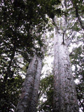 We woke up the next day to almost blue skies for our
drive through the Waipura Kauri Forest. The
road through the forest reserve on sharp switchbacks.
Near the top was the entrance to see the largest Kauri
tree in NZ. The Tane Mahuta, at 2,000 years old, is 51 M
high and 13.5 M in girth. Truly a giant tree, the NZ
equivalent of the California redwoods. A little further
on, we stopped to hike down well maintained paths to see
more giants of the forest. We spent about two hours
admiring the trees and enjoying the peaceful atmosphere.
It made us glad that all logging of the Kauri has been
stopped.
With an overnight in Warkworth, an hour north of
Auckland, and a brief stop in Auckland for chores and
lunch, we made it to Thames, on the southwest coast of
the Coromandel Penninsula. Our goal was to do a three day
hike in the nearby Kauaeranga Valley. On Wednesday we
stopped at the local information bureau where we were
able to phone the DOC (Department of Conservation) office
and reserve the next night at Pinnacles hut. The second
night was to be camping in our tent at Moss Creek as
there was no hut. After getting our food supplies ready
and loading our backpacks with everything for three days,
we set off Thursday morning for the DOC office to inquire
about the condition of the trails. As we had feared, Moss
Creek was not an option due to the wet and muddy
condition of the trails. That meant we could leave our
tent, stove and thermarest mattresses behind at the DOC
office, thus lightening our load. If the weather was
good, and we could find some other good trails, we left
our options open to stay at Pinnacle another night.
The trail up to Pinnacle Hut took us under three hours
and was over well maintained, quite wide paths. The
weather was perfect for hiking, not too many clouds but
not too warm either. We had good views of the valleys and
hills all day. We followed the Web Creek track up, which
entailed crossing Web Creek four times over sturdy
suspension bridges. A
large section of the trail climbed rather steeply up the
hill on steps, cut into the stone. These were constructed
in the 1920’s to enable pack horses to carry supplies to
kauri loggers, working in the forest up to six months of
the year. Pinnacle Hut was large and well maintained.
Trampers are housed in two dorms, each with 40 beds.
There were less than 30 trampers that night. Everybody
shares one cold water shower, a few outhouses and a large
kitchen. Surprisingly, it works very well. A school group
of two teachers and ten 13 year olds arrived for a school
end outing. The rest of us were glad when the Hut Warden
relented and housed the kids by themselves in the second
dorm.
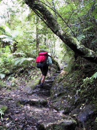
First you walk up the steps
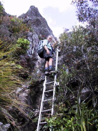
Then you climb the ladder
The day was still nice and sunny, so after lunch on
the pleasant balcony, Ray and I set off to hike to
Pinnacle Summit. To reach the base
of the hill, we had to negotiate fifteen minutes of mud.
We were glad we had our high, waterproof boots and
gaiters on. Other people with sneakers or short boots
ended up with muddy soakers. Once the trail started
uphill, we left most of the mud behind and clambored up
the steep rocks instead. The top section had two ladders
bolted to the rockface to aid in the ascent. Despite
this, there were plenty of hand and footholds and we had
no problems. The views at the top made the climb
worthwhile. We could see in all directions, including
towns on the east coast of the penninsula. We were told
we struck it lucky with the weather, as it is often windy
and cloudy at the top. We knew this was true for the
clouds started to descend on the mountains that evening.
By night it was raining again and the next morning we
decided it was time to leave. It was raining lightly, but
steadily when we left, but about half way down it stopped.
We decided not to press our luck, so there were no breaks
on the way down. Two hours saw us back at our car. Soon
we were back to town, just in time for the rain to start
again. I think we made a good decision.
Return to
Episode 1: Page 1 Auckland to Russell
Read about our visits to the
Cook Islands or
Fiji
Return to
New Zealand
Intro
Return to
Travels
Return to
Introduction