On The Gringo Trail
Episode 6: Attitudes and Altitudes
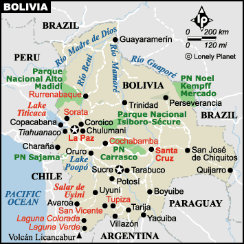
Click
the map above to see a photo
album of Lake Titicaca. Close the window to return to this page.
Read
Previous
High Desert Tales
or Read
Page 2 of 2
Tuesday January 28,
2003 Arequipa, Peru
Continued from Page 1
It was an overcast day with low clouds over the hills
when we left La Paz for Copacabana, on Lake Titicaca, the
following Sunday. We had great last views of the city
from the bus window and then we were on our way. The bus
trip was easy and we were even served complimentary
coffee and tea on our journey. A little after two hours
later we reached the tiny settlement of San Pablo de
Tiquina on Lake Titicaca. The shortest
route to Copacabana involves a five minute ferry ride
across a strait to rejoin the highway on the other side.
The bus travels on a barge across the water, but it is
not considered safe for the passengers to remain inside.
Instead we all got off and boarded small boats to take us
across. Bolivia is a landlocked country but it maintains
a Navy on Lake Titicaca. The dock was right next to a
naval checkpoint, which we had to clear.

The bus rides the ferry across Lake
Titicaca
Back on the bus, we continued on, up hills on a
peninsula where we could look down on both sides to the
lake below. Lake Titicaca is 230 K long, 97 K wide and at
3820M, is the highest navigable lake in the world. The
waters are supposed to be a beautiful blue but it was
overcast and rainy for our trip, so it was hard to tell.
After a short journey, we descended to Copacabana
surrounding a lovely bay. We found a good hotel room with
a view of the lake and settled in.
The town is a favourite vacation spot for Bolivians,
and despite the cold, rainy weather, many families were
down by the water having their pictures taken with pet
llamas, renting paddle boats and kayaks, and playing
foosball. This is a mechanical soccer games on raised
tables with the players manipulated by twisting poles
protruding from both sides of the game tables. I used to
have a hockey game like foosball. We watched the
festivities until it started to rain in earnest and we
headed to the safety, if not warmth, of indoors. Some
restaurants have portable heaters, but most homes and
hostels do not. Thank goodness for lots of blankets.

the 11th station of the cross on Cerro
Calvario (Calvary Hill)
It did clear up
enough the next day for us to climb two hills to enjoy
the view. In the morning we walked up Cerro Calvario,
which in 1946 had 13 concrete crosses erected on a wide
cobbled path leading to an upper altar. Pilgrims who
follow this route leave stones as homage to Pachamama on
each of the stations of the cross. At the top (3966 M)
were booths where women sold soft drinks for the thirsty
and souvenirs to remember the walk. Most of the booths
also had large displays of miniature cars, houses, small
storefronts (tiendas) and fake money for sale. People buy
the miniature of whatever they are hoping to acquire in
the next year and have them blessed at a special festival
at the local Cathedral on January 24. I bought small
trucks for our grandsons Tyler and Ryan but I really
think they are too young to own the real thing. Besides,
they will be unblessed.
The local Cathedral is huge, considering the size of
the town. It was constructed in Moorish style between
1605 and 1920. The main buildings are all white topped
with blue mosaic covered domes. Inside is a room devoted
to the Virgin of Copacabana. Twice daily people decorate
their cars or trucks with flowers and rosettes and drive
to the church for the vehicle blessing. We later
travelled in a bus that proudly displayed a banner
proclaiming it had the benediction of the Virgin of
Copacabana.
That afternoon was still nice
so we headed out to climb another hill beside the town to
see the Horca del Inca. This brought us even higher than
our morning walk. We had to pay an admission fee, higher
for foreigners, to see the Horca, but we weren’t going to
turn back. The Inca ruin was two upright pillars of rock
with a cross bar of rock, a la Stonehenge. Interesting,
but I didn’t find out the meaning, except for the fact
that festivities are still held there later in the year.
We climbed past the Horca to the very top of the rocks
getting a good panorama of the lake and surrounding
countryside.

Horca del Inca

Ruins on Isla del Sol
Just offshore from Copacabana is the Isla del Sol,
birthplace of the Sun according to Inca mythology. We
were hoping for a sunny day and planned to stay overnight
on the island, but the weather was overcast and drizzly
in the morning.
We boarded our excursion boat along with about 50
others anyhow and motored slowly out through the waves.
Once we passed to the sheltered side of the island it was
a calmer and quicker trip but it was still raining
lightly. We landed at a tiny village at the north end of
the island where we were met by a guide who herded the
majority of us off to see our first Inca ruins. Nearly
everyone else intended to return to the boat that day,
either to visit the Isla de la Luna before heading back
to Copacabana, or to walk to the south end of the island
where the return boat could be picked up. For this
reason, we were led at quite a fast clip over a headland
to the site of the ruins. A large flat rock was pointed
out that supposedly was in the shape of a puma head,
symbol of life on earth. I had
a hard time seeing the face but this is the site of the
birthplace of the sun. Across from the rock was a large
stone slab table surrounded by stone stools where animal
sacrifices are still made during a festival on June 21
each year. About 100 meters away were the ruins of a
large temple complex, that once housed 30 people in
multiple rooms. Except for missing roofs, the stone walls
were in very good shape.
The tour ended there, but Ray and I stayed behind to
eat our picnic lunch in the shelter of the stone walls.
After lunch we found the well marked ridge trail leading
to the south end of the village. It was supposed to take
three hours to walk the trail, but it was still drizzly,
so we didn’t stop too often or too long along the way. We
reached the village at the south end at 3 PM and started
to look for a hostel for the night. The first one didn’t
look very promising and neither did the weather, so Ray
suggested we just return to Copacabana on the 4 PM boat.
We were booked on an afternoon bus out of Copacabana the
next day anyhow. I didn’t object, so we joined several
others for a cup of tea while we waited for the boat. We
didn’t even feel like searching for other Inca ruins at
that point.
We were leaving Bolivia the next day to enter Peru and
our Bolivian money supply was running out, so back in
Copacabana we went looking for a less expensive hotel
than our previous choice. We got a real bargain at a new
place for B$20 ($4-5 CAD), including a bathroom with hot
water shower. We settled in comfortably as the rains
started in earnest for the night.
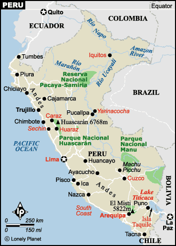
Click
the map above
to see a photo album of Arequipa and Colca Canyon. Close the window to
return to this page.
The next day we took the bus to Puno, Peru. It was an
easy ride and the border crossing was quick, but the
rains followed us to Puno. We were getting burned out
coping with cold rain so, for that reason, we only stayed
overnight and missed the fabled floating islands.
Instead, we took another bus the next morning to
Arequipa, where we still are.
It actually looked like a nice day when we left Puno
and stayed sunny as we made our way across deserts to
Arequipa. We found a nice, quiet hostel, Posada de
Cacique, with an inner courtyard in the center town. In
fact it is almost right next door to the one our niece
and nephew Nadia and Nicholas Scipio stayed in last
summer.
Arequipa is a large city but the center retains a lot
of the original Spanish charm. The large Plaza de Armas
is green and leafy and is surrounded on all sides by two
story white stone buildings with covered, arched
sidewalks. Restaurants on the upper terraces on two sides
make a good spot to enjoy a snack or meal and watch the
local scene. We have been trying out several of the
restaurants and visiting a museum or two.

Plaza des Armas

Monasterio de Santa Catarina
courtyard
We
took a guided tour of the huge Monastario de Santa
Catarina complex, encompassing more than a city block.
This was a cloistered convent begun in 1580, and enlarged
in the 17th century for the daughters of the Spaniards
who for one reason or another chose not to marry. Until
the South American Independence revolution in the 1820s,
the nuns lived simply in their own individual homes,
complete with servants. After the revolution the nuns
lived a communal life, sleeping in long dormitories and
eating in a common dining room. About 450 nuns and lay
people lived in the complex at its height, but they never
ventured beyond the walls of the enclosure, even in death.
In 1970 the population drastically reduced, the complex
was turned over to a private organization who restored
most of the original buildings and opened it to the
public. No one in Arequipa had ever seen what lay inside
before. There are still about 30 nuns who now live in a
separate more modern building in one corner of the
complex. It was a beautiful and peaceful spot with many
gardens and attractive narrow streets.
We also visited the Casa Morales, once the private
home of one of the original Spanish colonists, partially
destroyed by earthquakes in the 1940s and then lovingly
restored by a British man who amassed a huge collection
of paintings and colonial style furniture and lived in it
for forty years. It is now owned by a local bank, once
again restored and opened to the public. Included in our
small entrance fee was an informative guided tour by an
English speaking girl, who obviously cherishes the
contributions of the native people who made the furniture
and painted the pictures.
A highlight of our trip to Arequipa was a
visit to the Colca Canyon. We had heard good reports of a
hike down into the canyon, so that is what we did. We
joined 15 other people for a minibus tour to the Canyon.
We stopped to see llama, alpaca and vicuna herds along
the way to Chivay, the principal town in the region.
Vendors selling souvenirs were waiting at every stop,
dressed in colourful traditional costumes.

Vendors in traditional clothing
selling souvenirs

A condor flies over the high cliffs
We were brought to a restaurant for lunch, then to our
hostel in Chivay. At four oclock we assembled again to
walk less than an hour down the canyon valley to the
Thermal baths. There were two large pools that were about
35- 37 C, fed by local hot springs. We all had a good
time just relaxing in the warm waters. After our soak we
were driven back to town to change and get ready for a
late supper. The service was a bit slow at dinner, but
the entertainment made up for it. The restaurant caters
to all the Colca Canyon tours and has local musicians
play traditional music all through dinner. They were
excellent and played for more than two hours without a
break. One local couple performed several dances, dressed
in traditional costume. Several of the towns have
festivals in early February that include several days of
these dances so it remains popular with the locals. For
two of the dances, audience members (not me) were asked
to participate. They were taken out and dressed in
costume and performed the simple dances very well to
their obvious enjoyment.
The next morning we were herded into the minibus
shortly after 6 AM to drive to the Cruz del Condor, home
to about 35 Condor families. The most opportune time to
see these huge birds fly is between 7 and 9 AM. On the
ground they are not that attractive, as they are a
vulture variety, but in the air they are king. They are the
national bird of Chile and were revered by the Incas as
symbols of the upper life. The skies were cloudy when we
started out and our guide, Cesar, said we might not even
see any Condors as they don’t fly into clouds. We arrived
at 8:15 to quiet but clearing skies. Soon the first
Condor was spotted heading out over the canyon. We got
lucky. There were not many Condors about, but they were
riding in drafts that brought them low enough for us to
see their white ruffs and huge black and white bodies.
This is where Ray and I said goodbye to the main tour
group. We joined a young French couple, Damien and
Charlotte and took off in a local bus with our hiking
guide, Marcial. We drove about 1/2 hour further down the
canyon to the town of Cabanaconde. Colca Canyon extends
100 K between steep mountains with a swift, muddy river
running along the bottom. We had planned a circle walk of
the canyon, down past several small towns on the north
wall of the canyon to an Oasis at the bottom where we
would spend the night. The next morning we would climb up
1200 M on the south wall of the canyon back to
Cabanaconde. Again, the best laid plans go astray. Rains
had caused a landslide wiping out part of the trail
leading to the villages and damaging the bridge across
the river at the bottom. That meant we walked up and down
the same trail. It turned out well. It was a beautiful
sunny day and stopping several times for photo ops, we
were down at the Oasis in 2 1/2 hours. On the way,
Marcial pointed out several of the medicinal plants and
picked off some fruit from a cactus plant that is a main
crop in the area. I think it is the same as a prickly
pear and was juicy and delicious.
We found our home
for the night, a simple bamboo hut with a comfortable
raised bed. There was a refreshing swimming pool for us
to cool off in before a late lunch. Marcial promised to
take us for a walk after lunch up the opposite side of
the canyon so that we could see the view further up the
river. At 4:30 PM, after the hot sun had left the
hillside, we set out. Charlotte was having trouble with
her boots so Damien returned with her not far from the
top. We continued on with Marcial until we were on a
plateau looking down on the towns on the sides of the
hills. It was worth the climb and good practise for the
next day.

Oursimple but comfortable hut

We even had a swimming pool
At supper we joined several others at the communal
dinning table set outside in the trees and traded travel
stories. We all went to bed early as we had to get up
before 5 AM in order to hike up before the sun baked the
trail.
We did get away at 6 AM and the walk up was fine. We
didn’t stop for photos this time as we had taken many the
day before. Instead our breaks came whenever a donkey or
mule train passed us. There were many of them, most
heading back down the valley after delivering their crops
of fruit grown on the valley floor to the town above. We
were very pleased with our walk and thought we did very
well, reaching the crest in 2 1/2 hours, although the
locals do this every day. From the crest it was only
another 10 minute walk across corn fields to the bus stop
in town, where we got the 9 AM back to Arequipa.
It took 3 hours to reach Chivay, where we had spent
the first night. It can’t be more than 50 K but the bus
stopped continually to let locals off and on. We had an
hour break at the bus station, and then it was an easier
three more hours to Arequipa.
We got a taxi back to our hostel, Cacique, and settled
in once more, however briefly. We leave tomorrow
afternoon to fly to Lima and catch another flight to
Piura, just south of the Ecuador border. It is far
cheaper to take a domestic flight than to fly from Peru
directly to Ecuador, so we will travel across the border
to Guayaquil by bus. From Guayaquil we will get another
flight to the Galapagos islands for an extended visit. I
have heard nothing but glowing reports of the islands, so
we are looking forward to this trip.
Back to Episode 6: Page 1
Return to
Travels
Return to
Introduction