On The Gringo Trail
Episode 7: Igor and Friends
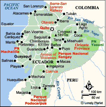
Click
the map above to see a photo album of Quito and
Baños. Close the window to return to this page.
Read Previous
Attitudes and Altitudes
or next
Page 2 of 2
Sunday February 16,
2003 Baños, Ecuador
Continued from Page 1
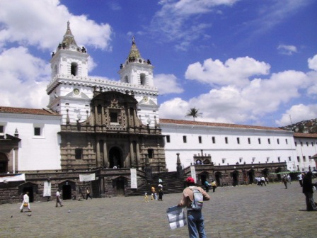
San Francisco Plaza Quito
We flew from the Galapagos to Quito, so we had to
get used to higher altitude again. I started sipping coca
tea, using the coca leaves I bought in La Paz. This
concoction is reputed to help acclimatise you to the
altitude, but you cannot buy it in Ecuador. I guess it is
too close to troublesome Columbia. We only stayed a day
and a half in Quito, but we enjoyed walking around the
Old City, admiring the Spanish architecture.
Otavalo, north of Quito, has a great Saturday market,
specializing in handicrafts. We could not wait around
until Saturday, but we decided to go and visit anyway. It
is only a scenic two hour bus ride from Quito, so we were
there in time for lunch. The vendors were in full force
in one of the town squares and were very pleased to see
us, as business was slow. Ray was quite patient as I
toured every single booth before making my purchases. We
had been putting off buying souvenirs as we didn´t want
the extra weight in our bags, but we could not put it off
forever. I made a good dent in our gift and souvenir list.
Now we are waiting to see what Cusco, our last
destination, has to offer.
We did a little people watching in Otavalo as well.
Quito people wear contemporary clothing, but most of the
women in Otavalo, and some of the men, wear a colourful
traditional outfit. The women wear multiple strands of
gold bead necklaces and an embroidered white blouse with
puffy sleeves. Their skirt is a black sarong overskirt
open at one side to show a white underskirt and on their
feet they wear a cloth sandal. Both men and women had
their long black hair in a single braid down their back
and nearly everyone wore a black or green fedora. Most of
the men wore contemporary clothing, but some of the older
men had on white pedal pushers and a striped poncho for
warmth.
Rather than stay longer in Otavalo, we left the next
day to travel back to Quito where we transferred to
another bus bound for Latacunga, another two
hours south. The whole trip was through the mountains of
Ecuador, past several volcanoes. We missed seeing one of
the highest, Cotopaxi, because clouds were obscuring the
top, but it was a pleasant route.
We went to Latacunga to make two side trips, one to
visit the local Thursday market in nearby Saquisili, and
the other to visit Lago Quilotoa, a volcanic crater lake.
Our original plan had been to take local buses to these
destinations. That would have meant a day trip to
Saquisili and possibly an overnight trip to Lago Quilotoa.
Instead, we made inquiries in town and ended up getting a
guide to take us to both places in the same day.
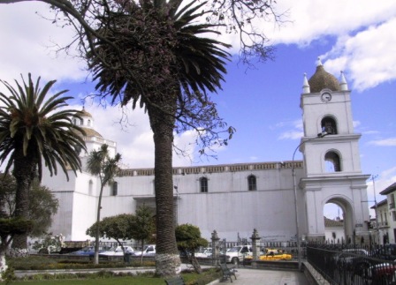
Latacunga Cathedral
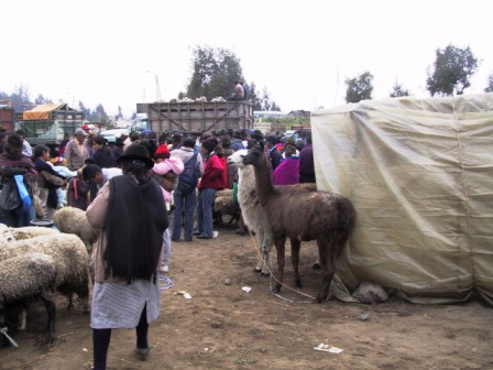
Llamas for sale at Saquisili Market
It was a long but rewarding day. Our guide, Ramiro,
picked us up in his 4WD vehicle at 7:30 AM on Thursday
and off we went to Saquisili. We could tell we were
getting close as the road was crowded with farm trucks
and other vehicles. This is not a tourist market. Every
Thursday people from farms and small villages in the
surrounding mountains come to Saquisili to trade animals
and goods. The small town is given over to many different
markets. We visited three main areas. The first one was
the animal market. I am sure that Ray’s father would have
felt right at home, except there was not an auction.
Instead, the farmers unload their livestock from the back
of their truck and tether them to a spot on the ground.
Then prospective buyers wander about comparing the
animals and finally making their purchases. There were
lots of Holstein cows, sheep and pigs for sale, as well
as some Llamas, goats, donkeys and mules.
From the animal market, Ramiro took us to another area
where fruit, vegetables, fish and meat were sold. There
were a few booths offering rugs and other tourist
souvenirs, but that was not the main purpose. The locals
far outnumbered the few tourists there. My only
disappointment was that unlike Otavalo, there were very
few people in traditional dress, except for the fedora.
Everyone seems to have embraced the more contemporary
look.
The third market area we visited had more fruits and
vegetables, but it also had a section offering live
poultry, rabbits and even guinea pigs. We have yet to
sample the Ecuadorian delicacy of cuy (guinea pig). One
thing that puts us off is the presentation. It is usually
served whole with the head and little paws still on.
After we had had our fill of the markets, Ramiro drove
us through the hills to Lago Quilotoa. The route was
spectacular, winding past ever changing vegetation until
we reached the altiplano at 4000 M. We passed reforested
areas of eucalyptus and pines, green cultivated fields,
sheep pastures and finally grasslands, the home of the
llama. A bit further we stopped to look down into deep
sandstone canyons, formed by rivers, which were dry at
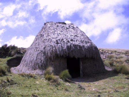
this time of year. In one of the highest areas the local
people build their homes from the long grasses that grow
in tufts over the hills. We
stopped to look inside one of the straw huts that was
empty at this time. An open doorway opened into one small
windowless room with a dirt floor. Ramiro assured us it
was very snug and comfortable but I like a little more
comfort.
Lago Quilota grass hut
We stopped again to visit a workshop in the village of
Tiloa. The people of this village specialize in painting
colourful scenes of village life and legends on wood and
sheep skin. We have seen this artwork for sale elsewhere
in Ecuador and it is often very well done.
We finally reached the village of Lago Quilotoa close
to noon, parked the car and walked over to the lookout to
see the lake. You
look down from the rim of the volcano at 3850 M to see a
green jewel of an alkaline lake 300 M below. It is
possible to walk on the rim all around the lake, but that
would take up to ten hours and judging from where we were
standing looking down, would be a windy hike. We were not
going to attempt that. Instead we wanted to walk down to
the lake. There is a popular option to ride a mule for
the return trip up the hill, but we were not going to
take the easy route. We figured we needed the practise
for our future Inca Trail walk, so we walked down and up.
Ramiro wisely waited for us at the top. He has done this
before.

Lago Quilota volcano from rim of
volcano
Quilota herd of sheep on trail
The path started in a cleft in the soft sandstone
sides of the volcano. It was well marked and not very
difficult. One long section was fun to go down. The
sandstone had crumbled into a sand dune that you could
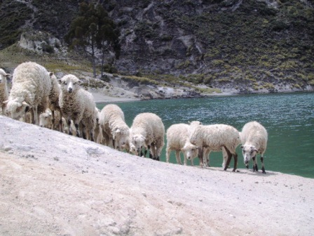
dig your heels into and bounce down. Near the
lakeshore we passed flocks of sheep being herded by
locals. A few llamas and cows were also grazing on the
sparse vegetation of the hillside. We reached the shore
in just over a half hour and dabbled our hands in the
water to discover it wasn’t very cold. We had passed two
Dutch girls riding up on mules and learned later that
they had gone swimming in the lake, but we had not
thought to bring our suits.
We were hungry for some lunch so after looking around
and taking pictures, we started the uphill climb. That is
when we realized we were at 3500 M and the path was steep.
That sand dune that was such fun to run down was murder
going up. Your feet sink in and slip back with each step.
We had lots of rest stops along the way to have a drink
of water and catch our breaths. I started thinking
wistfully about those mules, although I do not like
riding. We persevered though and made it to the top in
under an hour. Ramiro was impressed. He said most people
take 1 1/2 to 2 hours for the return trip, so I guess we
were not as bad as we thought.
We were glad to tuck into the food Ramiro had brought
for us. Refreshed, we headed home, awing again at the
mountain scenery as we bounced along the rough road back
to town.
From Latacunga we went just a little farther south to
Baños. It is a pretty little town in a narrow valley in
the middle of the Andes. Since it is only 1800 M high,
the steep hills are lush and green. Baños is known for
its thermal baths, but we haven’t taken advantage of them
yet. Instead, we have been biking and hiking.
The first day we
rented mountain bikes to follow the Route of the
Waterfalls. It was supposed to be 60 Km “mostly
downhill” from Baños to Puyo, due east. We started
out straight downhill, as advertised on a nice paved road
beside a river through a narrow canyon. Just the kind of
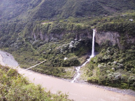
riding I like. We stopped to admire the many waterfalls
which shot down off the steep mountain sides to the river
below.
Waterfall on bicycle ride to Puyo
At about the 8 Km mark we had to go through a short
tunnel. Thank goodness there was no traffic and we could
see light from the exit, because there was no other
lighting. Another tunnel loomed before us but it had a
notice saying “no bicycles”. There was a bike
detour on the old road next to the river. It was great.
By this time we were at least 100 M above the river and
we had a great view, plus we didn’t have to worry about
that tunnel. The downside was that the paved road ended
after the tunnel. It was a rough ride for the next 20 Km
but that is why we had mountain bikes. We had a few
uphills that let us realize that this ride was not a
piece of cake. We were glad to take a break at the 20 Km
mark. There was a big sign pointing to a path down
towards the river, promising a waterfall viewpoint. The 1
Km walk down was steep but easy and the waterfall was
spectacular. However, steep down means steep uphill so we
paid for the easy descent.
Back on the bikes we passed the last of the waterfalls.
The valley from then on gradually got a bit broader and
Halleluia, we got a paved road again for the last half.
We also got an unscheduled break to sit out a downpour. I
think this is a regular occurrence in the mountains. It
looked like it was clearing so we pushed on. We passed
one young couple on one of the unadvertised uphills where
the girl had to get off and walk up the hill. I think
they turned back before finishing as we never saw them
again.
The second half of the route is known for the wild
orchids growing beside the road and for a large tea
plantation that we stopped to admire. The vegetation was
pure tropical, different from the barren mountains of the
higher altitudes.
We made it all the way to Puyo, right to the bus
terminal. We were able to put our bikes on top of a bus
and travel in relative luxury back to Baños. It was fun
seeing the road over again, although both of us thought
it was scarier in the bus. you don’t realize how narrow
the road is when you are on a bike. There were sections
that were only wide enough for one vehicle. We even had
to back up once to let a bus travelling the opposite
direction pass us. We arrived back in Baños tired but
very pleased with our day.
Today we put on our daypacks, bought a sandwich and
set out up a trail on the south side of town. They don’t
believe in easy switchbacks around here. Straight up is
shorter but harder. Our first goal was a Mirador (look
out), complete with lit up cross, about 300 M above town.
We found out you can take a taxi ride all the way up if
you don’t like walking, but of course we walked. It was a
good view, both east and west out of the valley, but the
highest peaks were still covered in clouds. We wanted to
see the Volcan Tongurahua. That meant we would walk
farther up the mountain side. We walked part way on a
cobblestoned road that led into a beautiful little
resort, Luna Runtun. A local stopped us and asked where
we were headed. He advised us to follow a path through
the woods that would lead to a great Mirador of the
Volcano. We took his advice and chugged up more steep
paths until more than an hour later we found ourselves on
a ridge with almost a 360 view of the mountains and
valleys. Just the spot for lunch.
No worry: machete at tea is not
serious
The local man had said that Tungurahua clears every
afternoon between 2 and 5 but when we were at the top it
was still cloud covered. We started down again on an even
steeper path through the woods, that did come out on the
local road. A little further down the road we were
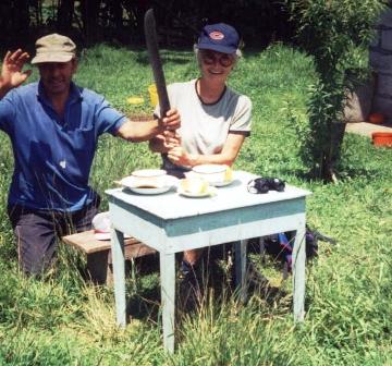
stopped by another local who introduced himself and asked
if we would come to his house for tea. He said we would
have a good view of Tungurahua from his cottage, just
beside the road. That sounded like a good idea so we
agreed to his suggestion. He set up a bench and a small
table for us in the pasture beside his tiny cottage and
made us a herbal tea with lemon and fresh buns. The
clouds did part enough for us to see the top of the
volcano, just as he had promised. We paid him a dollar,
which was welcomed, said our good byes and continued down
the hill back to town.
We are not quite ready to leave Baños yet. There are
more trails to follow and it is a nice relaxing place to
spend some time. We are planning a few more stops in
Ecuador before making our way to Cusco in Peru at the
beginning of March. Who knows what adventures we can come
up with next.
Back to Episode 7: Page 1
Return to
Travels
Return to
Introduction